Our planet needs constant monitoring. From tracking delicate ecosystems to mapping farmlands, AI models are becoming crucial tools for making smart, data-driven decisions. But here’s the catch: analyzing satellite imagery on a global scale can be incredibly expensive in terms of computer power.
That’s where innovation comes in.
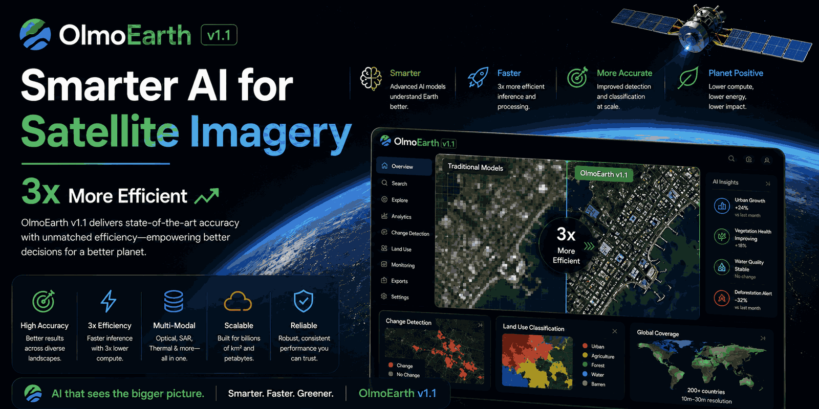
AllenAI recently dropped OlmoEarth v1.1, a big upgrade to their powerful AI models built for remote sensing. The exciting news? This new version promises to cut your computing costs by up to three times – all while keeping the impressive performance of its predecessor, OlmoEarth v1. This means organizations working to protect our planet can access AI that’s more affordable, scalable, and sustainable.
Why Does Efficiency Matter So Much in Satellite AI?
Imagine needing to analyze satellite images across hundreds of thousands of square kilometers to watch subtle changes in forests or coastlines. This isn’t just a one-time thing; you often need frequent updates to get timely insights. The whole process – from exporting and preparing data to making predictions (inference) and post-processing – demands a lot of computer power.
For projects monitoring ecosystems, climate change, or agricultural yields across entire countries, continents, or even the whole globe, compute costs can easily become the biggest hurdle. A more efficient AI model means lower operational expenses. This allows more partners to use this technology faster and more often, truly driving OlmoEarth’s mission: giving communities and organizations cutting-edge AI to protect people and the environment.
The Secret to Speed: How OlmoEarth v1.1 Does It
At its core, OlmoEarth uses transformer-based models, which are a big deal in modern machine learning. To make sense of vast satellite data, these models first break down raw imagery into smaller, digestible pieces called “tokens.” How efficient these models are really boils down to two things: the model’s overall size and the length of these token sequences. Here’s a key point: compute costs can grow quadratically with token sequence length. That means even small reductions can lead to huge savings.
A Smarter Way to Process Satellite Data
One of the main challenges in building effective remote sensing models is figuring out how to turn complex satellite data into these tokens. Take Sentinel-2 imagery, a common input for OlmoEarth. This data usually has spatial dimensions (height and width), a time dimension (timesteps), and multiple spectral channels.
In older versions, OlmoEarth would divide this data into patches. For each patch, it would create a separate token for every timestep and every spatial resolution available (like 10m, 20m, and 60m). While effective, this meant a single Sentinel-2 input with just two timesteps could generate six tokens per patch (two timesteps x three resolutions). Multiply that by thousands of patches, and you quickly get very long token sequences and high compute requirements.
OlmoEarth v1.1 introduces a clever new trick: it merges the different spatial resolutions into a single token per timestep per patch. This simple change effectively cuts the token count by a factor of three!
Of course, just combining tokens could sometimes lead to a performance drop – it might make it harder for the model to see important relationships across different spectral bands. But the brilliant part of OlmoEarth v1.1 is that it achieves this reduction without losing performance. The team specifically tweaked their pre-training process to ensure these merged tokens still capture all the vital information for accurate analysis. You can dig into the deeper technical details in their official tech report.
Key Benefits of OlmoEarth v1.1
This efficiency boost brings some serious advantages for anyone working with satellite data and AI:
- Big Cost Savings: You get up to a 3x reduction in compute costs for processing and making predictions, making advanced analysis much more affordable.
- Same Great Performance: Crucially, these savings don’t mean less accuracy. OlmoEarth v1.1 performs just as well as v1 across various research benchmarks and real-world tasks.
- Better Scalability: Lower costs mean you can deploy the AI more often and across larger areas. Imagine updating planet-scale maps not just once a year, but quarterly or even monthly!
- Increased Accessibility: By lowering the financial barrier, more organizations, researchers, and developers can use this cutting-edge AI for crucial environmental monitoring.
Who Benefits? Developers and Researchers
OlmoEarth v1.1 was built with practical applications in mind for two main groups:
For Developers
If your team is currently using an older OlmoEarth model, upgrading to v1.1 could give you an immediate advantage. You’ll see significantly cheaper and faster fine-tuning and inference cycles, making your planet-scale mapping and monitoring projects more flexible and cost-effective. While the technical report mentions a few minor regressions for very specific niche tasks, for most applications, the performance is comparable to v1 with a huge reduction in compute. This makes frequent map refreshes and large-scale deployments much more achievable.
For Researchers
Pre-trained remote sensing models are complex, with many factors influencing how they behave. When a model’s performance changes, it can be tough to figure out if it’s the architecture, the training data, or the pre-training method causing it. OlmoEarth v1.1 offers a unique advantage for scientific study. Since it’s trained on the same dataset as OlmoEarth v1, any differences in behavior or performance you observe can largely be linked to the changes in its pre-training and tokenization strategy. This gives you a clearer path to understanding core scientific principles in remote sensing AI development.
Real-World Impact and What You Can Do With It
The original OlmoEarth models have already shown their power in many ways:
- Tracking Mangrove Changes: Monitoring these vital coastal ecosystems to understand their health.
- Identifying Causes of Forest Loss: Pinpointing why deforestation happens to help with conservation.
- Creating Country-Scale Crop-Type Maps: Helping with agricultural planning and food security.
With OlmoEarth v1.1, these critical tasks become even more efficient and widespread. This improved efficiency means AI for good can scale further and faster, reaching more communities and organizations dedicated to preserving our natural world.
Get Started with OlmoEarth v1.1
Ready to dive into efficient remote sensing AI? You can get your hands on the OlmoEarth v1.1 models right now. They come in various sizes (Base, Tiny, and Nano), so you can pick the best fit for your budget and specific project.
- Explore the Models: Check out the OlmoEarth v1.1 weights.
- Dive into the Code: Find the training code on GitHub.
- Read the Details: For a deeper technical understanding, read the official Tech Report.
Frequently Asked Questions (FAQ)
What is OlmoEarth v1.1?
OlmoEarth v1.1 is an updated family of AI models from AllenAI, designed for analyzing satellite imagery and remote sensing data. It’s built to be much more efficient than its previous version, OlmoEarth v1.
How does OlmoEarth v1.1 save on computing costs?
It saves costs by cleverly changing how satellite imagery is turned into “tokens” for the AI model. By combining information from different spatial resolutions into a single token, it reduces the overall token sequence length by up to three times, which significantly lowers how much computer power is needed.
Does OlmoEarth v1.1 perform as well as v1?
Yes, OlmoEarth v1.1 matches the performance of OlmoEarth v1 across various research benchmarks and real-world tasks, even with its reduced computing needs.
What kind of data can OlmoEarth v1.1 analyze?
OlmoEarth v1.1 is primarily designed to process remote sensing data, like Sentinel-2 satellite imagery, for tasks such as environmental monitoring, mapping land cover, and analyzing agriculture.
Final Thoughts
The release of OlmoEarth v1.1 is a big step forward, making advanced AI for environmental monitoring more practical and accessible. By focusing on efficiency without sacrificing performance, AllenAI is empowering a broader range of developers and researchers to tackle some of our planet’s most urgent challenges. This innovation truly highlights a key trend in AI development: it’s not just about building bigger, but building smarter and more sustainably.
If you’re looking for ways AI can contribute to a greener future, OlmoEarth v1.1 offers a compelling, cost-effective solution for large-scale geospatial analysis.